
How to Read a Plat Map: A Homeowner’s and Homebuyer’s Guide
When buying, selling, developing, or researching real estate, understanding exactly what land is included with a property is essential. One of the most useful documents for doing that is a plat map, sometimes called a parcel map or assessor’s map.
At first glance, a plat map can look intimidating—filled with numbers, lines, abbreviations, measurements, and oddly shaped parcels. Once you understand the basic symbols, however, it becomes a valuable tool for learning more about a property.
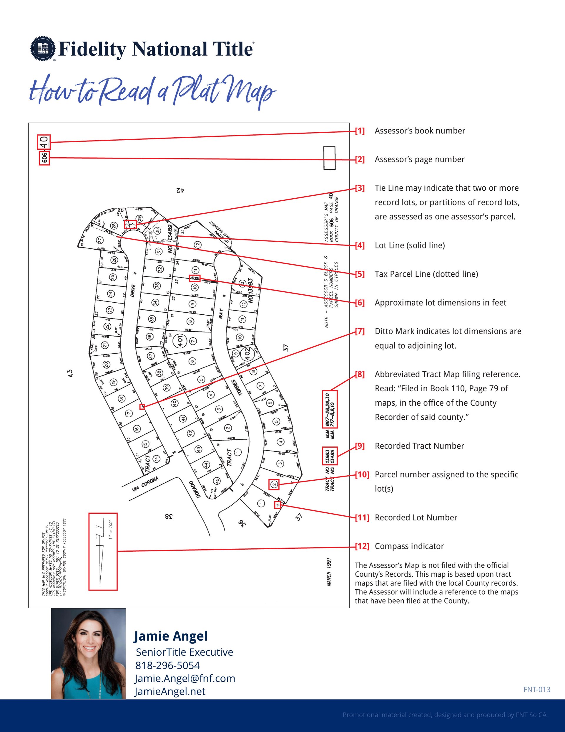
Using the Fidelity National Title example above, here is a simple guide to what you are looking at.
What Is a Plat Map?
A plat map is a map showing how a larger area of land has been divided into individual lots, parcels, streets, tracts, and other geographic divisions. Depending on the map and jurisdiction, it may also provide dimensions, parcel numbers, recorded lot numbers, tract references, and other information that helps identify a particular piece of real estate.
Plat maps are particularly useful when you want to understand where a property sits in relation to neighboring lots and streets.
One important distinction: an assessor’s parcel map is generally intended for property identification and taxation purposes and should not automatically be treated as a boundary survey. When precise legal boundaries are important, consult the recorded documents, title company, and, when appropriate, a licensed land surveyor.
The 12 Key Elements of a Plat Map
The example provided by Fidelity National Title identifies several important features:
1. Assessor’s Book Number
This identifies the assessor’s map book in which the property is located. It is one component used by the county assessor to organize parcels.
2. Assessor’s Page Number
This identifies the specific page within the assessor’s book where the parcel appears.
3. Tie Line
A tie line may indicate that two or more record lots—or portions of record lots—are being assessed together as one assessor’s parcel. This can be particularly important because one tax parcel does not necessarily equal one recorded legal lot.
4. Lot Line
Solid lines generally indicate the boundaries between individual lots shown on the map. These lines help you visualize the shape and configuration of the property.
5. Tax Parcel Line
A dotted line can represent a tax parcel division. Pay attention to the difference between tax parcel lines and recorded lot lines because they do not necessarily represent the same thing.
6. Approximate Lot Dimensions
Numbers alongside parcel boundaries may indicate approximate dimensions in feet. For example, a parcel might show approximately 70 feet of frontage and 120 feet of depth.
These measurements can help you understand the property's general size and configuration, but they should not replace a professional survey when exact measurements matter.
7. Ditto Mark
A ditto mark indicates that a particular dimension is the same as the corresponding dimension of an adjoining lot. This prevents the map from becoming unnecessarily crowded with repeated measurements.
8. Tract Map Filing Reference
This tells you where the underlying tract map was officially recorded. A notation may refer to a particular book and page of maps in the County Recorder's records.
This reference can be extremely useful when additional research is needed.
9. Recorded Tract Number
Subdivisions are commonly assigned tract numbers. The tract number can help identify the recorded subdivision in which the property is located.
10. Parcel Number
This is the parcel number assigned to the specific property or lot shown on the assessor's map. It is commonly associated with the property's Assessor's Parcel Number (APN).
An APN is extremely useful for locating tax and assessor information, but remember that an APN is primarily an assessor's identification system—it is not, by itself, the property's complete legal description.
11. Recorded Lot Number
The recorded lot number identifies the property's lot within the applicable subdivision or tract. You may see legal descriptions using language such as:
“Lot 12 of Tract No. _____, as per map recorded in Book ___, Page ___ of Maps.”
The actual legal description should always be obtained from the appropriate recorded documents or title information.
12. Compass Indicator
The compass or north arrow tells you the map's orientation. This allows you to determine which direction the property faces and how the parcel is positioned relative to streets and neighboring properties.
Why Plat Maps Matter When Buying a Home
A plat map can reveal information that isn't obvious from simply touring a property.
Imagine walking through a beautiful backyard and assuming everything inside the landscaping belongs to the home. A plat map may help you recognize that the parcel's configuration is different from what you expected—or that additional research is warranted.
For buyers, reviewing available maps and title information can help raise important questions about lot configuration, access, adjoining parcels, recorded lots, and potential easements or restrictions.
However, a plat map alone usually does not answer every question. Easements, CC&Rs, rights-of-way and other title matters may require reviewing the preliminary title report and the underlying recorded documents.
Why Plat Maps Matter to Sellers
Sellers can also benefit from understanding their property's parcel configuration before putting a home on the market.
Knowing the approximate lot dimensions, APN, tract and lot information can help ensure that property information is presented accurately and can help identify questions that should be addressed before escrow.
This becomes particularly important with large estates, unusual lots, hillside properties, multiple parcels, vacant land, development opportunities, and properties that may consist of more than one recorded lot or APN.
Plat Map vs. Property Survey
One of the most important things for consumers to understand is that looking at a plat or assessor's map is not the same as having the property professionally surveyed.
A map can help you understand the property's general configuration. A licensed surveyor can physically determine and document boundaries based on the applicable records and field evidence.
If you are planning to build a pool, guest house, ADU, fence, retaining wall, addition, or other improvement near a property line, relying solely on an assessor's map can be risky. Appropriate surveys, title information, zoning requirements, setbacks, easements, and local building regulations should be investigated.
A Useful Tool for Smarter Real Estate Decisions
You don't need to be a surveyor or title professional to learn useful information from a plat map. Start with the APN, lot number, tract number, dimensions, parcel lines, street locations, and compass direction, and then use the recorded references to investigate further when necessary.
For buyers, it can help you better understand what you're purchasing. For sellers, it can help you better understand what you're marketing. And for investors and developers, it can be an important starting point when evaluating the potential of a property.
Thinking About Buying, Selling, or Developing Property?
Real estate is about much more than bedrooms, bathrooms, and square footage. Understanding the land beneath the home can be just as important.
If you're considering buying or selling a home, vacant land, an estate property, or a potential development opportunity in Westlake Village, Thousand Oaks, the Conejo Valley, Calabasas, Malibu, or the greater Los Angeles area, I can help you navigate the property information, coordinate with title and other appropriate professionals, and ask the right questions before you make an important real estate decision.
Tina Lucarelli | Luxury Real Estate Advisor
Helping buyers and sellers understand the details behind the property—not just the house. (310) 738-8089